


List Of Nature Reserve in Singapore
| NATURE RESERVE | DETAILS | WEBSITE |
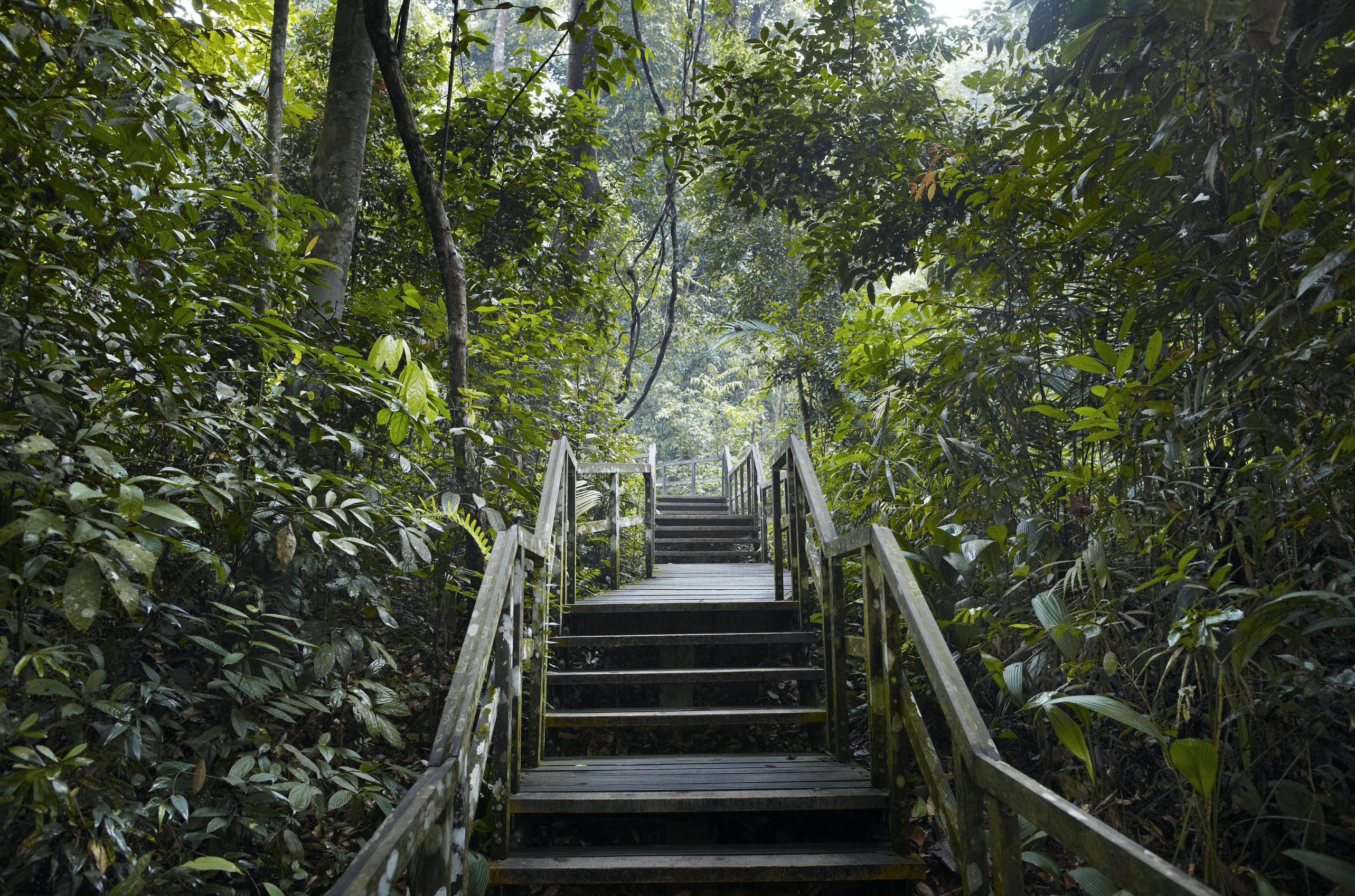
| Central Catchment Nature Reserve | How to get there: Start from Venus Drive Carpark to TreeTop Walk. Bus Stop ID: 53079, 53071(Upper Thomson Rd) Nature Reserve Opening Hours: 7am to 7pm (entering or remaining in the nature reserve after 7pm is not allowed) TreeTop Walk Opening Hours: Weekdays: 9:00am to 5:00pm Weekends and Public Holidays: 8:30am to 5:00pm Closed on Mondays (except Public Holidays) Last entry at 4:45pm Venus Drive Carpark Opening Hours: 7am to 7pm daily |
https://www.nparks.gov.sg/gardens-parks-and-nature/parks-and-nature-reserves/central-catchment-nature-reserve |
| Bukit Timah Nature Reserve |
How to get there Nature Reserve Opening Hours Exhibition Hall Opening Hours: 8am to 5.30pm daily Carpark Opening Hours: 7am to 7pm daily |
https://www.nparks.gov.sg/gardens-parks-and-nature/parks-and-nature-reserves/bukit-timah-nature-reserve |
| Labrador Nature Reserve |
How to get there: Alight at Labrador Park MRT station Park size: 22 hectares Nature Reserve opening hours: 7:00 am to 7:00 pm daily (entering or remaining in the nature reserve after 7:00 pm is not allowed) Park and Berlayer Creek lighting hours: 7:00 pm to 7:00 am daily Carpark Opening Hours: 24 hours daily |
https://www.nparks.gov.sg/gardens-parks-and-nature/parks-and-nature-reserves/labrador-nature-reserve |
Nature reserves in Singapore
Introduction
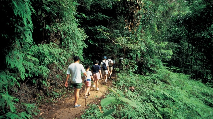
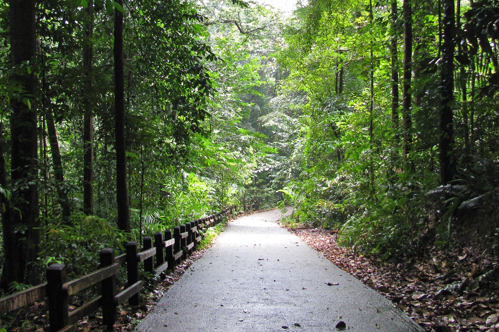
Want to take a countryside stroll? These nature reserves offer everything from boardwalks and sky-high walkways to family-friendly jungle hikes in Singapore!
It’s common knowledge that space is limited in Singapore. Fortunately, there are trees and green areas everywhere you look to balance off the metropolitan skyline of tall buildings. The stunning Gardens by the Bay on the island is one of the Top 10 Indoor Gardens in the World. Visit one of Singapore’s four nature reserves if you wish to explore the country’s lush surroundings. An abundance of wildlife native to the island that you may see.
Which is the largest nature reserve in Singapore?
The Central Catchment Nature Reserve, which covers 2880 hectares, is Singapore’s biggest nature reserve. It forms a sizable green lung in the geographic center of the city. It is home to several leisure destinations, such as the Singapore Zoo, Night Safari, and River Safari, and more recent amenities created to promote public enjoyment of the reserve, like the HSBC TreeTop Walk.
The Central Water Catchment‘s limits include the reserve. One of Singapore’s four gazetted nature reserves is this one. The other three are Labrador Nature Reserve, gazetted on January 1, 2002, Sungei Buloh Wetland Reserve, and Bukit Timah Nature Reserve.
The Parks & Trees Act of 2005 protects the four natural reserves within the parks. For the nearby reservoirs, the nature reserve serves as a catchment region. This reserve contains the MacRitchie, Upper Seletar, Upper Peirce, and Lower Peirce reservoirs, the largest in the nation. In contrast to Bukit Timah Nature Reserve, where the forests are still mostly untouched, most of the CCNR’s forests get removed for logging and farming. The CCNR today consists of young and old secondary forests with virgin primary forests encircling the reservoirs.
Why are nature reserves significant in Singapore?
The establishment of NParks in 1990 to oversee the national parks, which at the time included the Singapore Botanic Gardens, Fort Canning Park, and the nature reserves, resulted in developing a more unified philosophy for nature preservation. The Parks and Recreation Department and NParks amalgamated in 1996 to consolidate park operations under a single umbrella group.
The NParks organization is now in charge of breeding, safeguarding, and maintaining “the animals, plants, and other organisms of Singapore and, within the national parks, nature reserves, and public parks, to preserve artifacts and locations of aesthetic, historical, or scientific interest.” The Animals and Birds Act, Control of Plants Act, Endangered Species (Import and Export) Act, Parks and Trees Act, and Wildlife Act are just a few of the laws that NParks is responsible for enforcing to safeguard Singapore’s flora and animals.
Singapore joined the International Trade in Endangered Species of Wild Fauna and Flora Convention in 1986. (CITES). Currently, it is one of the 183 nations subject to a global agreement that establishes a licensing system to control the international trade in threatened wild species of animals and plants. Ong Pang Boon, who was the environment minister at the time the CITES treaty was signed, said, “the [Southeast Asian] region was at the crossroads of a developing worldwide trade on flora and fauna, which if allowed unchecked may lead to the irrevocable loss of valuable species.”
What are the 4-nature reserves in Singapore?
Bukit Timah Nature Reserve
This magnificent patch of equatorial forest is the ideal getaway from the bustle of the city and is located right within the city limits. The Bukit Timah Hill, which occupies a portion of this 163-hectare natural habitats reserve, is Singapore’s highest point. Along well-marked hiking and mountain bike trails, it’s a terrific area to take in the forest sights, sounds, and forest fragments. It’s one of the top 4 natural forests in Singapore and is ideal for family vacations where kids can discover the local flora and animals.
Central Catchment Nature Reserve
Two primary water catchments in Singapore, one of which is the Central Catchment Nature Reserve. The three nature trails offered here are the Walking Trail, which will take you to the TreeTop Walk, the Chemperai Trails, which will take you along the edge of the reservoir, and the Prunus Trail. And immerse you in the dense rainforest and perhaps even allow you to spot the critically endangered Banded Leaf Monkey.
Sungei Buloh Wetland Reserve
Sungei Buloh Wetland Reserve is a magnificent sight when the birds are migrating. Before they go for another expedition, you can observe flocks of sandpipers and plovers residing within the reserve. See local marsh creatures with mudskippers, monitor lizards, and water snakes throughout the year.
Labrador Nature Reserve
You may be sure to enjoy the sea wind and the sound of crashing waves at Labrador Nature Reserve, which is close to Singapore’s southernmost point and home to the nation’s only coastal cliff. It is one of the few lovely spot where you can legally fish if you’ve always wanted to. 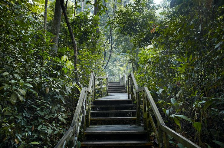
Do’s and Don’ts
Try to “Leave No Trace”
Only take pictures and leave footprints. Wildflowers, antlers, boulders, and arrowheads are a few examples of the resources that may not get taken out of the park. Remove any rubbish and litter; this is perhaps more crucial than eliminating a few errant rocks. Ensure that all trash gets disposed of in trash or recycling bins, or better yet, bring reusable containers.
Don’t feed the animals.
Although animals are cute and may appear hungry, feeding wild animals is not a good idea and is not permitted in national parks. Animals shouldn’t eat human food since it can have health consequences. Additionally, it reduces the natural fear the wild animals have of humans, endangering animal species and human safety.
Be mindful of food storage laws when camping, and resist the impulse to feed those lovely little animals.
Don’t approach animals too closely.
Never approach an animal to the point where you can influence its behavior. The animal is also at risk, in addition to you. Federal law prohibits purposefully reaching, loitering, or remaining near wildlife at any range that disturbs or disperses the animal. Visitors must keep at least 300 feet away from wolves and bears and 75 feet away from bison, elk, and other wildlife.
Never vandalize
People seem to need to stamp their identity on things for whatever reason. Everything damaging and unpleasant, from initials and names, etched into rocks to spray paint on trees! Graffiti removal is never simple, and the time and money spent on such attempts are both needless and expensive. Unreplaceable natural features may suffer considerable harm from sandblasting and some chemical strippers.
Do not smoke while hiking.
National parks have no-smoking zones on their paths. Instead of breathing in secondhand smoke, people visit parks to enjoy the fresh air of nature. It is also a fire hazard, which is more critical. Unfortunately, the wildfires that have occurred this year get started by people.
Avoid loud music playing.
It’s impolite and disrespectful, although this isn’t a strict regulation. Listen to music while hiking, but don’t assume else on the trail feels the same way. It’s a win-win if you just put on some headphones.
Not Flying Drones
Kindly refrain from using your drone or other aircraft in a national park. Maintaining both peace and avoiding fines will result from doing so.
Which is the largest nature reserve in Singapore?
Four nature reserves in Singapore, with the central catchment nature reserves being the largest nature park at 2880 hectares. This natural reserve, which is in the geographic core of our nation, serves as the city’s Verdant lungs and a source of clean air for the entire continent. It also acts as a catchment region for our four main reservoirs, Mac Ritchie, Upper Seletar, Upper Pierce, and Lower Peirce. These reservoirs offer a constant supply of fresh water. The densely populated vegetation in nature reserves encourages rainfall. The Singapore heat gets lessened by doing this.
The Central Catchment nature reserve and Bukit Timah nature reserve hold most of the remaining primary forest, lost in large portions. The Central Catchment nature reserve contains a rare forest type known as the Primary freshwater swamp forest, a unique sort of Singaporean ecosystem. Only a tiny part of these natural ecosystems get effectively protected in the Nee Soon Swamp Forest due to human activity, which has led to a large portion of them getting converted for other use
Come and discover these biologically diverse forests, which are home to over 500 species of creatures, including the Banded leaf monkey, the smaller mousedeer, and the Sunda pangolin. If you’re fortunate, you could catch a glimpse of these local creatures on your hikes. The banded leaf monkey’s conservation also depends on the central Catchment Nature Reserve. These species are at risk of going extinct due to urbanization. Now living in the wildlife reserve is the last remaining population of these monkeys. The National Biodiversity Centre has an ecological investigation to comprehend these species and put management strategies for their long-term preservation into place.
Bukit Timah Nature Reserve
The Bukit Timah Nature Reserve is Singapore’s second-largest nature reserve. It and the Central Catchment Area get divided by the Bukit Timah Expressway.
Bukit Timah Hill serves as the centerpiece of Bukit Timah Nature Reserve. It is a bulwark of some of the last remaining primary woods on the island and is Singapore’s highest hill at 163 meters.
During the Straits Settlements period in 1883, the Bukit Timah Forest Reserve and numerous other Forest reserves get created. Bukit Timah Forest Reserve was retained under Singapore Botanic Gardens supervision, although the forest reserves get finally exploited for timbre. However, the region was worked for granite, leading to quarries such as Hindhede Quarry, Singapore Quarry, and Dairy Farm Nature Park Quarry.
Designate Bukit Timah Nature Reserve as an ASEAN Heritage Park in October 2011. Visitors to the Bukit Timah Nature Reserve Visitor’s Center’s exhibition hall on the second level can find out more about what the forest at this Singapore nature reserve has to offer.
What is unique about Bukit Timah Nature Reserve?
The Bukit Timah Nature Reserve is Singapore’s first rainforest preserve, created to protect the local flora and animals. This reserve trail is today one of Singapore’s most popular tourist destinations. This reserve’s natural surroundings include unusual flora and fauna. The Bukit Timah Nature Reserve also has Singapore’s tallest hill, which is located there and rises about 163 meters above sea level. It makes it ]alluring for hikers and adventure seekers to set out on a trail to take in Singapore’s beauty from above.
It has a massive diversity of ecological systems, situated in Singapore’s tropical zone, and features some unusual trees and blooming flora exclusive to Singapore. In this reserve, you can find rattans, fig trees, lianas, Funghi, lichen, forest shrubs, and much more significant tropical secondary rainforest flora. Here in the coastal hill dipterocarp forest, you can also find a specific group of plant species known as Dipterocarpaceae.
The Bukit Timah Nature Reserve’s hiking trail can be enjoyed by one and their loved ones; the unusual animals, exotic wildlife, and Unadulterated nature will captivate you. Carpenter bees, paradise tree species snakes, macaques that eat crabs, colugos sun skinks, and many more large species can get observed here. Greater racket-tailed drongo, Asian fairy bluebird, red-crowned barbet, and emerald dove are unique birds spotted in Bukit Timah.
Central Catchment Nature Reserve
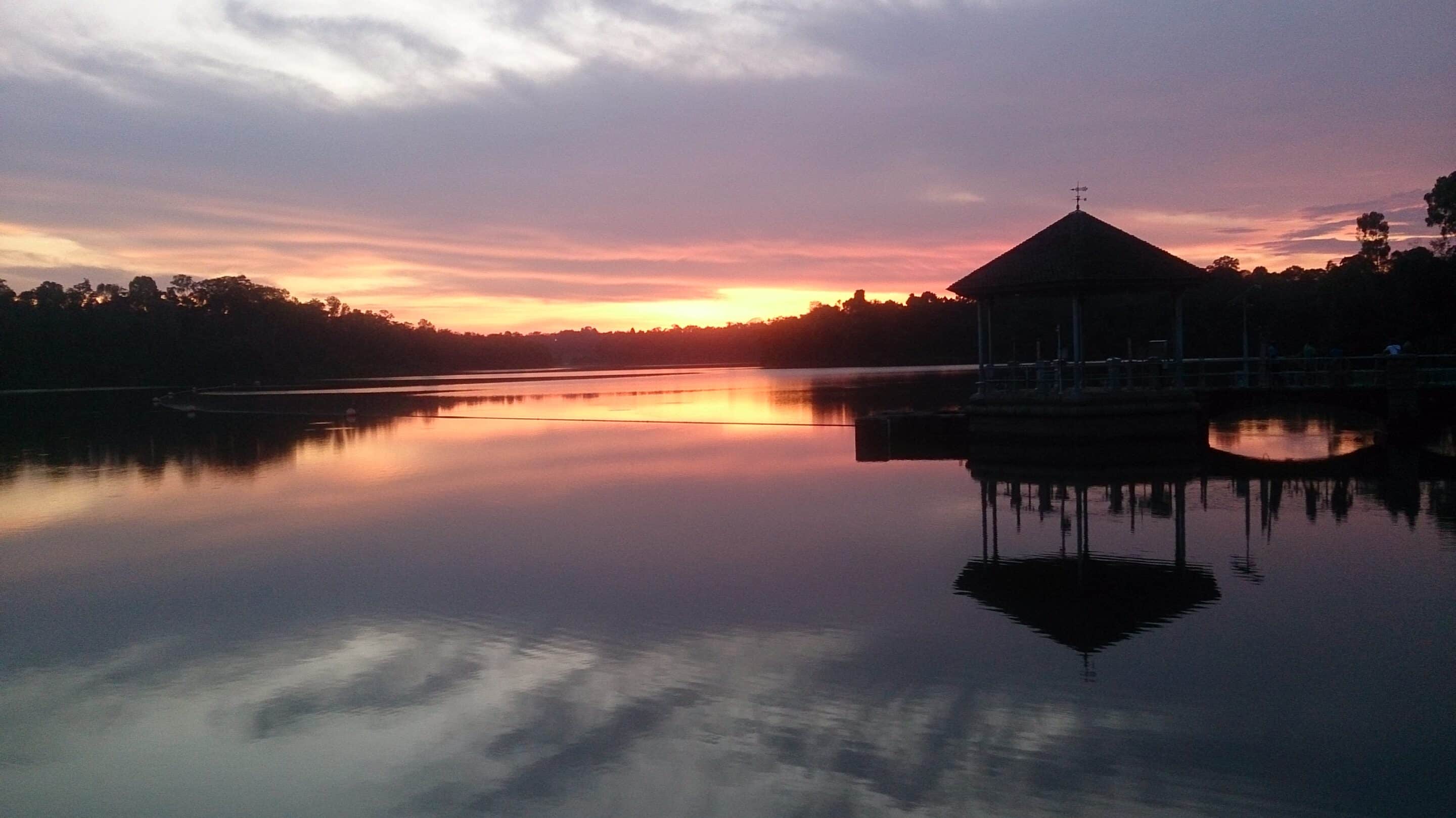
Singapore’s Central Catchment Nature Reserve is the biggest. If you consider hours-long hikes in the woods while constantly running the risk of getting lost to be a true nature adventure, the lovely park would likely be the closest thing to satisfying you. The Upper Peirce, Peirce, MacRitchie, and Seletar reservoirs’ surrounding forests provide the majority of this reserve’s vegetation. Old Upper Thomson Road leads to the Upper Peirce Forest, and Lornie Road leads to the MacRitchie Reservoir Park, where the park’s southern section get s located.
One of the attractions of Singapore’s Ecotourism and Nature Reserves and 18 Best Parks and Natural Spaces is the Central Catchment Nature Reserve. Since there is no entrance fee to the Central Catchment Nature Reserve, there is also no visitor center, and you are on your own. The forests in the Central Catchment get secondary forests, in contrast to the Bukit Timah Nature Reserve.
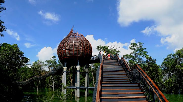
As the park continues straight on to Bukit Timah Reserve and beyond, you can hike quite a ways here. Explore the several stages of the mature secondary forests in the nature reserve from a height of around 25 meters by taking on the TreeTop Walk, a freestanding 250-meter suspension bridge. Bring a hat, apply sunscreen, and stock up on plenty of drinking water before visiting Central Catchment Nature Reserve and going on excursions in the forest to protect yourself from the intense equatorial sun.
How big is the Central Catchment Nature Reserve?
The Central Catchment Nature Reserve, located in the heart of Singapore, serves as a sizable green lung. The Central Catchment Nature Reserve, the largest nature reserve in Singapore, covers more than 2,000 hectares of land with trees and is home to some of the most biologically diverse woods. The reserve’s Jelutong Tower, a seven-deck observation tower with unrestricted forest views, is a well-liked destination. Also accessible to visitors is the Nee Soon Swamp Forest, a unique primary freshwater swamp forest.
Sungei Buloh Wetland Reserve
A natural forest cover the establishment of an ecological balance in the area is the Sungei Buloh Wetland Reserve in Singapore. The public knows this reserve forest’s significance as a yearly stop for migratory birds. Although it covers 130 hectares, an internet search would have you believe the reserve is 202 hectares large. Nevertheless, this vast reserve is home to hundreds of exotic species of both plants and animals. Because of the reserve’s beauty and distinction, it gets included in the 2013 list of ASEAN Heritage Park.
What animals are in Sungei Buloh Wetland Reserve?
The birds are the main draw of the Sungei Buloh Wetland Reserve’s fauna. Numerous birds eating the park’s mollusks and worms get seen throughout the migratory season. The common redshank, yellow bittern, whimbrel, curlew sandpiper, cinnamon bittern, and other species are among those you can find here and are worth mentioning in particular.
You can see a wide variety of wild animals, including otters, giant mudskippers, Malayan water monitor lizards, banded archerfish, mud lobsters, tree-climbing crabs, golden orb-web spiders, St. Andrew’s cross spiders, weaver ants, saltwater crocodiles, milky storks, whistling ducks, greater spotted eagles, higher crested.
Who built Sungei Buloh?
In 1986, the government and other wildlife specialists joined forces to launch a communal effort to ensure its protection. Sungei Buloh was recognized as a nature park and opened its doors in 1993, thanks to its heroic efforts. During the opening ceremony on December 6, 1993, Mr. Goh Chok Tong (second from left), Singapore’s then-prime minister, strolls along the Main Bridge.
Singapore’s first wetland reserve gets gazetted as a nature reserve in 2002 following ten years of preparation and community backing. The site officially joined the East Asian-Australasian Shorebird Site Network that same year and was designated as a site of international significance for migratory birds.
How long is Sungei Buloh walk?
Sungei Buloh’s walk is 3.2 kilometers long and takes 43 minutes to complete on average. You’ll probably run into other people while exploring because this is a popular location for birding, hiking, and walking.
Labrador Nature Reserve
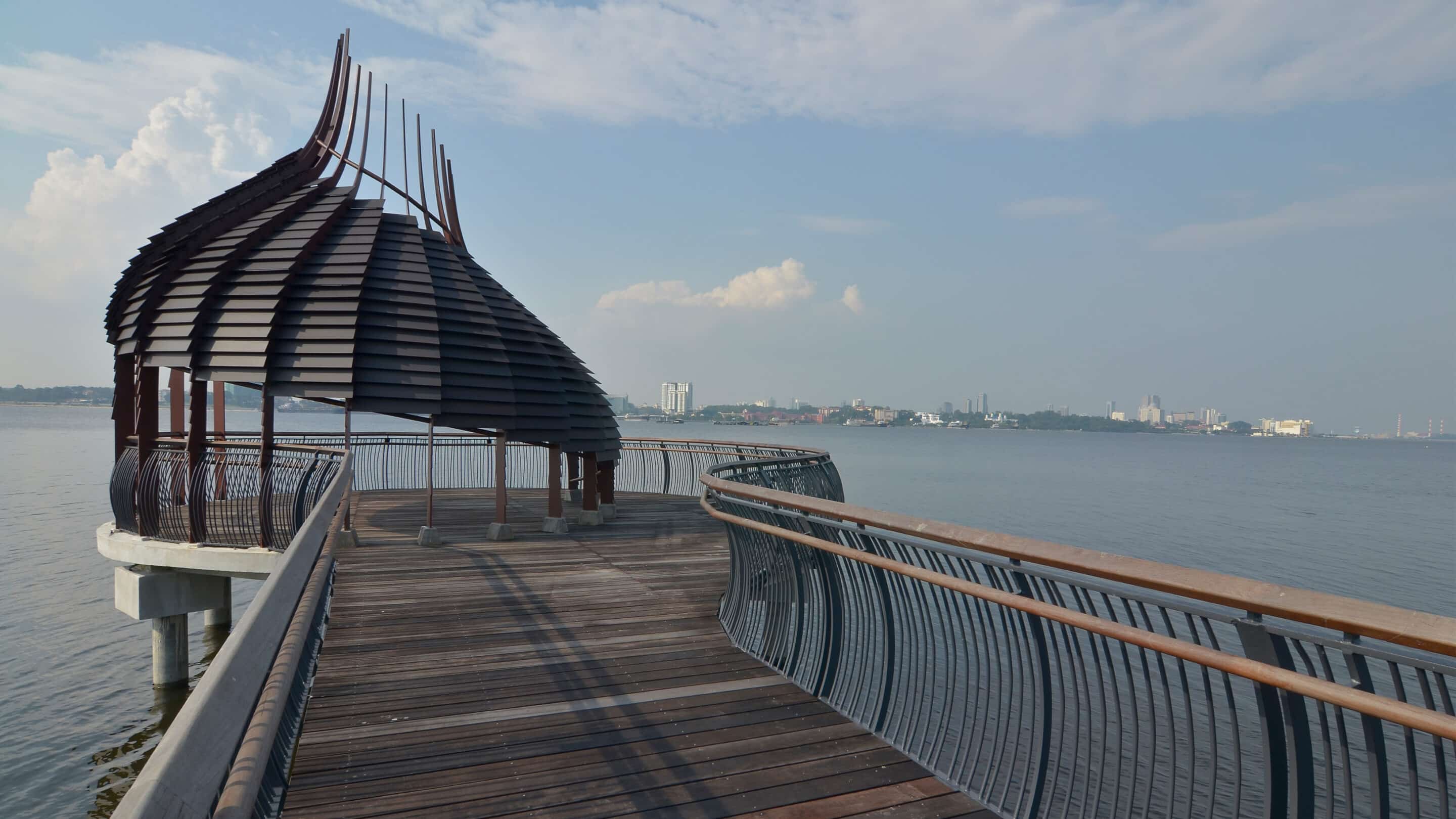
The Labrador Park Nature Reserve, commonly referred to as the Labrador Park locally, is located in the southern portion of Singapore’s main island. It just has a rocky seacliff that is easily accessible to the public on physical aspects. Its rocky reserve and around 10 hectares of coastal vegetation get protected as part of a natural reserve. The rufous woodpecker, blue-crowned hanging parrot, and Abbott’s babbler are just a few of the more than 70 species of birds that call this nature reserve in Singapore home. In addition to this, numerous species of butterflies reside here. In addition to sandworms, seagrasses, and horseshoe crabs, the rocky shore mentioned above is home to several crabs and corals.
How long is Labrador Nature Reserve?
The 2.1-kilometer Labrador Nature & coastal forest Walk, close to Labrador Park MRT Station, is divided into three sections: the Alexandra Garden Trail, the Berlayer Creek mangrove trail, and the Bukit Chermin Boardwalk.
Why is Labrador Park called Labrador Park?
The old defense battery, nature park, and designated reserve area known as Labrador Park/Fort Pasir Panjang are in Singapore’s Central Region. The name Labrador gets derived from “Labrador Villa,” the address of illustrious ship chandler George John Mansfield, constructed in 1881.
Guide to Labrador Park
Although Labrador Nature Reserve is the official name of the lovely green park tucked away by the sea, you may know it by the moniker Labrador Park. Great walking routes, historic British military fortifications, two kid-friendly playgrounds, and a cooling sea wind can all get found in Labrador Park.
Directions to Labrador Park
The 22-hectare Nature Reserve is simple to reach by public transportation due to Labrador Park MRT. After leaving the MRT at Labrador Park, proceed on foot along Labrador Villa Road, following the instructions, until you reach Labrador Park (it should take you about 15 minutes to walk). Taking the Berlayer Creek Boardwalk (more on this below) will take you to Labrador Park on the opposite side of Labrador MRT, but it will take more time.
Play areas at Labrador Park
A small play area with swings, a see-saw, and a merry-go-round is close to the Dragon’s Tooth Gate. There is also sand there for digging.
You’ll find a newer, Larger playground with slides, a fireman’s pole, a maze, and entertaining tunnels to crawl through on the other side of Labrador Park if you continue along the road along the water (beyond the restrooms and snack vending machines).
Labrador Jetty
One of the well-known fishing places in Labrador Park is the jetty, located at the far park end. On the weekends, the jetty gets lined with several anglers and fishing gear owners. Visitors may see the Pasir Panjang Container Terminal and some container ships docked across the water from this location. The jetty is a fantastic location for taking pictures of the Labrador Nature Reserve’s vegetation and sunsets.
Red Beacon
This magnificent Red Beacon was one of Labrador Park’s most recognizable buildings. The beacon gets displayed at the crossroads near the Port of Labrador. All approaching ships and vessels entering the island get guided by this beacon.
Dragon’s Teeth Gate
The Dragon’s Teeth Gate, also known as Batu Berlayar, is a landmark that ships and other boats can use to navigate. The rock gets later known by this name because of its shape, reminiscent of a dragon’s teeth.